
Trace a Franklin Township Street
A Franklin Township street search works best as a record trail, not as a single answer. Start with the exact address in the assessor's property search. Save the street form returned there, the parcel block and lot, any qualification, and separate mailing and situs values. The County GIS viewer then puts that parcel in its map setting. Its shapes and shared lines help distinguish a nearby lot from the target parcel.
Carry the parcel identity into the land index next. A recorded owner is not automatically a present household member, and a voter record or old directory entry has a different date and purpose. The method below keeps those roles apart. It also works when a street has route names, village labels, common ownership, public land, or a parcel without a conventional street number.
- Search the address in TaxDataHub with Property and Town Filter. Narrow a broad result with B.L.Q., class, sales, or year filters.
- Locate the block and lot in the Somerset County Tax Parcel Viewer. Select the parcel and note its geometry and neighbors.
- Use the legal description or block and lot in AcclaimWeb to locate the latest recorded instrument.
- Read grantor, grantee, document type, record date, and legal description together. Move backward only when the municipality and parcel details match.
- For a historical household clue, compare a directory street guide, newspaper, census image, or regulated voter-list request with the exact address and date.
Note: A parcel located, a recorded owner located, and a mailing address located are distinct findings; none alone confirms a current household.
Franklin Township Street Directory Fields
Franklin Township's assessor route is TaxDataHub, a county property interface whose visible filters support careful by-address work. Property accepts address text, while Town Filter keeps a regional query in the municipality. Owner Name supports a separate owner search, and the portal documents * for any number of characters and ? for one character. The data import date shown in the portal belongs beside any record copied into a street worksheet.
| TaxDataHub field | Input | Street-search use |
|---|---|---|
| Town Filter | Optional filter | Keep the query in Franklin Township. |
| Owner Name | Text | Check an owner name after a parcel is identified. |
| Property | Text | Enter the address or a narrow street form. |
| B.L.Q. Filter | Text | Bridge the address to block, lot, and qualification. |
| Class and Class4 | Filters | Narrow a broad street result by property class. |
| Sales Date and Price | Date and range | Limit results to a recorded sales period. |
| Building Sqft. and Year Built | Ranges | Differentiate similarly named parcels. |
| Sort by | Dropdown | Review available sort choices before export. |
| Download Excel | Control | Use only after a narrow result; the portal warns of a maximum. |
| Disclaimer I Accept | Conditional button | Accept before viewing results. |
The successful TaxDataHub search capture shows the Franklin Township property filters used for this route.
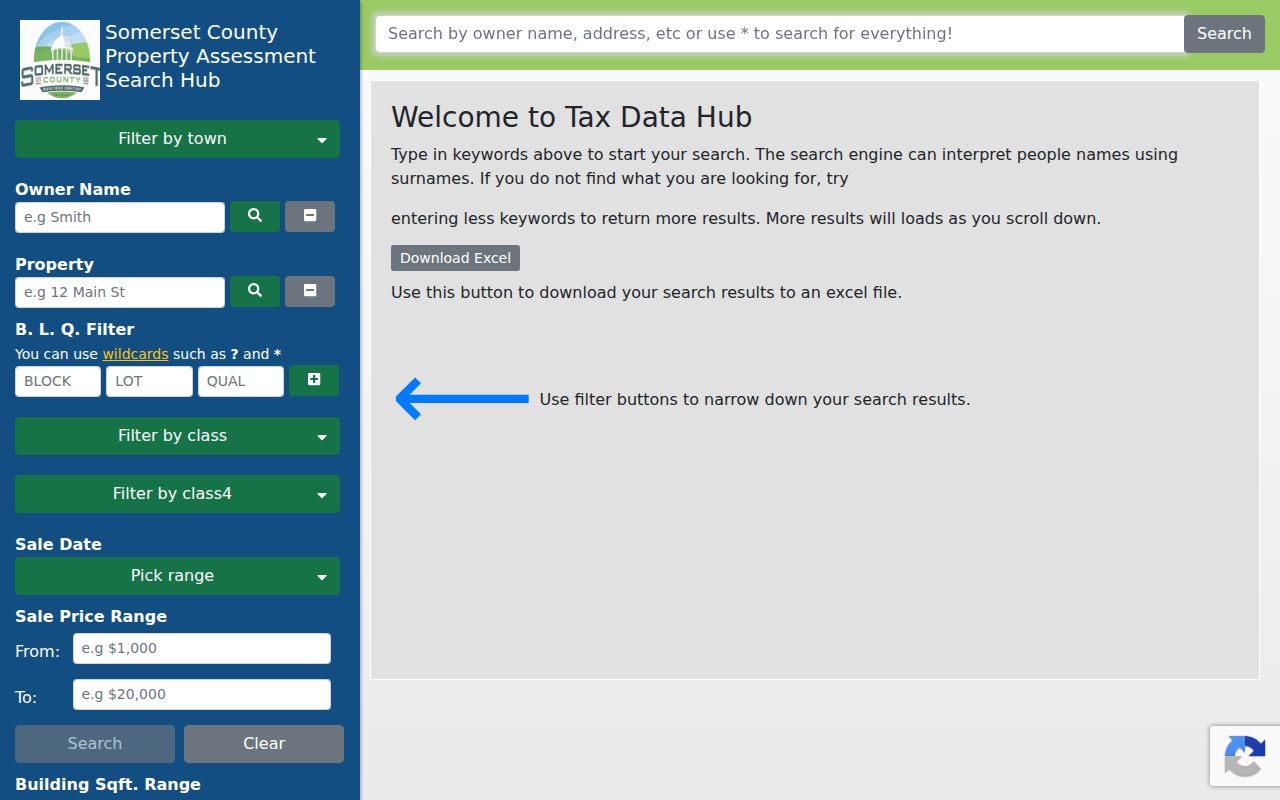
The screen is a parcel-research start, not a complete resident list. No ZIP field was visible in the inspected interface, and a partial export does not prove that a street has no additional records.
Franklin Township Records by Address
Franklin Township records are keyed to an address in different ways. The assessment roll centers on a current parcel and owner information. GIS centers on mapped geometry. The Clerk's land index centers on recorded parties and legal descriptions. Joining them with the street name is useful, but each source keeps its own date, field rules, and limits.
| Address record | Custodian | What it can establish | Access path |
|---|---|---|---|
| Assessment roll | Franklin Tax Assessor | Parcel, owner result, property details, and possible mailing/situs values. | TaxDataHub or assessor office. |
| GIS parcel | Somerset County GIS | Geometry, block/lot context, 200-foot tools, maps, and reports. | Public ArcGIS viewer and open data. |
| Deed and mortgage index | Somerset County Clerk | Recorded parties, type, date, legal description, and image. | AcclaimWeb, then older-record channels. |
| Construction permit | Franklin Construction Code | Address, block/lot, work, applicant, and permit-control evidence when public. | SDL portal, office, or OPRA route. |
| Planning or zoning material | Franklin Planning and Zoning | Specific-property, board, zoning, and land-development clues. | Department inquiry or OPRA request. |
| Historic-resource material | Franklin HPAC | District, property, review, and certificate context. | Historic districts resources. |
| Voter file | Somerset election offices | Regulated public fields supplied under election rules. | Specialized county request process. |
| Street guide or newspaper | Library and archives | A dated, published address or household reference. | Local history, microfilm, or digitized collection. |
A full Somerset voter-list request can be limited by municipality, voting district, or another stated area, but it remains a regulated request with protected-field redactions and political-use terms. It is not a household census, and voting history does not reveal ballot choices.
For a Franklin Township street directory result, label the source and date rather than merging rows into a profile. A deed controls its instrument, the assessor controls its roll, GIS controls map context, and a directory controls only what its publisher printed.
Map Franklin Township Streets Parcel by Parcel
The 2024 county update to the parcel viewer described address, block/lot, and property-class search, parcel selection, 200-foot notification or search tools, reports, maps, bookmarks, and basemap choices. Owner names are redacted in the parcel data. The viewer is therefore best for navigation and shared boundaries, not for naming every person connected to a block.
Open a Franklin Township address or block and lot, zoom to the street segment, select the target parcel, then generate a report or map if it preserves useful context. Carry the block and lot to TaxDataHub and the legal description to AcclaimWeb. The 200-foot tool is a notification or search aid, not a legal neighborhood boundary. It can cross a road, subdivision, village, or municipal line.
Franklin Township Street Directory Terms
Parcel records use terms that sound alike but point to separate parts of the Franklin Township trail. Keeping each term with its source prevents a street search from claiming more than its record supports.
- Parcel
- A mapped unit of land used in tax and GIS systems, commonly identified through block and lot values.
- Situs address
- The physical location of the parcel. It can differ from the owner correspondence address.
- Legal description
- The recorded land identity, such as block, lot, qualification, subdivision, or metes and bounds, used to confirm a deed.
- Plat
- A recorded map or plan that can show parcel layout, roads, or subdivisions when available in land records.
- Criss-cross directory
- A reverse street guide that lists a published address or number and its dated listed household or organization.
TaxDataHub calls the parcel filter B.L.Q. Its exact input syntax was not published in the inspected interface, so preserve the returned value rather than guessing a format for another system.
Read Franklin Township Deeds Along a Street
The County Clerk's online land-record instructions describe Name, Book/Page, Instrument Number, Legal Description, Document Type, Consideration, Record Date, and Alpha Index modes. Use the legal-description popup for municipality, block, lot, and other identifiers when a street query is too broad. For personal names, the Clerk instructs searchers to use Last, First M.; company names need their exact form.
After a result opens, check party roles in the instrument image. A grantor or grantee can be an estate, trust, company, or individual, so the street name alone is not enough. Index and image viewing are free after a free account and email activation, though images carry an unofficial watermark. The Clerk lists ordinary record-room copies at $.07 per page and certified instruments at $10 plus $1 per page. The office will explain computerized indexing but does not conduct title searches.
Records before January 1, 1977 follow the Alpha Index route. Continue with paper deed books or microfilm at the County Clerk record room, then verify the precise older volume or municipality through State Archives or FamilySearch research paths.
Franklin Township Street Directory Addresses
A Franklin Township property result can contain a situs address and a mailing address. The situs is the parcel's physical location. The mailing value is where tax correspondence goes. A difference can reflect a trust, estate, company, correspondence elsewhere, or an outdated roll. It is a lead for research, not proof that a person is at the situs.
The same caution applies to dates. A TaxDataHub import can differ from the date a deed was recorded, while an instrument can carry execution or acknowledgment dates in addition to its record date. Keep each date with the source. When results conflict, preserve the disagreement, parcel details, and date rather than selecting a convenient name.
Franklin Township Streets and Postal Names
Franklin Township has several postal and village labels. County materials associate its addresses with Franklin Park 08823, Somerset 08873, East Millstone 08875, Zarephath 08890, Kingston 08528, and a limited 08540 Princeton overlap. A postal place is not automatically the municipal boundary or tax jurisdiction, especially around Kingston and the 08540 overlap.
Use the USPS ZIP Lookup for a complete address, then retain its postal result alongside the Franklin Township municipality, GIS parcel, and legal description. Search road suffix variants and village labels as well. County records may use Somerset, Franklin Park, East Millstone, Kingston, Zarephath, New Brunswick, Somerville, or a directory code for a parcel now associated with Franklin Township.
Note: No official township street-renumbering or renaming year was located, so use block/lot, cross streets, route names, and historic maps instead of inventing a number conversion.
Franklin Township Street Permit Clues
Franklin Township Construction Code records can add a dated work trail to a parcel. The published contact route accepts an address, city, ZIP, and optional permit or control number. Its records can involve applicant or property address, block/lot, work type, inspections, and approvals. The SDL status portal and office are the first channels; an OPRA request is the fallback for a specific non-posted record.
Planning and Zoning asks for address, block/lot, and owner on specific-property inquiries. Historic Preservation Advisory Commission material can add a district or review clue around the D&R Canal corridor, East Millstone, Franklin Park, Kingston, and Middlebush. Neither a permit nor a historic review identifies a complete household.
Franklin Township Street Directory History
For a past Franklin Township address, use a historical street guide after the parcel and village labels are known. Regional Polk, New Brunswick, and Somerville volumes can include Franklin areas, but coverage must be checked volume by volume. The alphabetical section preserves a published name and address; the householder or street section can reverse-check the number. A municipality code such as SOM or SVILLE belongs to that publication's key and should not be carried into another volume without checking it.
The Franklin Township Public Library Historical Room offers reference-only material, a copier, and a microfilm reader or printer. Digitized newspaper and photo collections are separate from the physical holdings. The longer collection runs and catalog cautions belong on the Franklin Township city directory page; here, their role is to test a dated street number or household clue against the parcel trail.
Limits of a Franklin Township Street Directory
A street directory cannot produce a complete private household list. Assessment and deed records can identify a parcel or recorded party, but they do not establish every person at an address. Vehicle data is restricted by the federal Driver's Privacy Protection Act. Utility, delivery, private club, and unposted contact records are not a public by-address database. Voter records also have protected fields and regulated access rules.
Lawful use. Franklin Township street records are for personal, lawful research, family history, property questions, and civic context. Do not use an address trail to stalk, harass, intimidate, or harm anyone; New Jersey anti-stalking and harassment laws apply.
New Jersey's Address Confidentiality Program and Daniel's Law protections can limit public display of addresses. If a source appears protected or sensitive, stop short of republishing details and ask the responsible custodian about the correct process.
Franklin Township Street Records Before Numbers
Modern street numbers are not the only Franklin Township property trail. State Archives guidance lists surviving Franklin tax-ratable books for 1802, 1806, 1808, 1815, and 1825, with earlier Eastern Precinct material. These are pre-modern-address sources, so a farm, owner name, road line, map, and later legal description may be more useful than a house number.
That surviving sequence is a local records story. It can bridge an old map label to a later parcel search, but it cannot establish a modern street address without matching evidence.