
Franklin Township ZIP Code Coverage
Somerset County materials identify six address-level postal identities that can occur with Franklin Township records. They are useful search terms, but none should be treated as a municipal boundary by itself. The county's 2025 appendix lists Franklin Park, Somerset, East Millstone, Kingston, and Zarephath with Franklin Township. A newer county directory also lists the Princeton label. For a real address, the Postal Service result is the deciding check.
| Postal ZIP | Franklin Township association | Postal label | Research note |
|---|---|---|---|
| 08823 | Franklin Park | Franklin Park | Postal place and township boundary are not the same thing. |
| 08873 | Township mailing area | Somerset | Used by the municipal complex and listed by the county. |
| 08875 | Village-area identity | East Millstone | Listed in the county directory and ZIP appendix. |
| 08890 | Distinct postal identity | Zarephath | Verify a street address before treating it as an eligible result. |
| 08528 | Village crossover | Kingston | Kingston spans several county and municipal contexts. |
| 08540 | Address-level overlap | Princeton | The appendix calls out Franklin addresses only, not a township assignment. |
The research found no official ZIP-specific population totals, post-office hours, realignment history, or complete Franklin ZIP polygon map. This ZIP code directory therefore keeps the county's list intact and avoids drawing a line that official sources did not publish.
Franklin Township Postal Name Traps
Postal names can lead a search in the right direction while still describing the wrong government or parcel area. Somerset, Franklin Park, East Millstone, Kingston, Zarephath, and Princeton appear in local address work for different reasons. Kingston is especially easy to misread because its historic village context reaches Somerset, Mercer, and Middlesex counties. Keep the address as printed, then add the township and county as separate values when moving to a tax roll, a deed, or a court record.
Older material adds more variation. A directory may use a regional code such as SOM, SVILLE, or NB, and historic maps may call out a route, village, farm, or canal corridor instead of a modern postal label. The correct response is to test the village and postal variants together, not to rewrite one label as another.
Note: A postal city verifies mail delivery language, while a parcel record verifies the government area and land description.
Check a Franklin Township ZIP Code
The USPS ZIP Lookup is the address-level check for this work. Enter the complete street address, city, and state exactly as known. Its form is designed for a corporate or residential street address, so it confirms a postal answer for that submitted location rather than producing a township-wide resident list.
| USPS field | How it helps a Franklin Township search |
|---|---|
| Street address | Anchors the postal verification to one physical delivery location. |
| City | Tests the supplied postal label, which may differ from the municipal label. |
| State | Keeps the result within New Jersey before county records are checked. |
| Returned ZIP | Supplies the mail-routing value to preserve beside the parcel and township fields. |
Save the postal wording with the date of the lookup. A USPS answer confirms an address for mail purposes. It does not identify an owner, establish a current household, or establish a legal parcel boundary.
Find Franklin Township Records by ZIP
A ZIP code directory works as a careful sequence. Franklin's assessor search does not expose a ZIP field in its documented interface. The county GIS viewer is parcel geography, not ZIP geography. That means the postal result must be converted into an address or parcel search rather than pasted into an unsupported filter.
- Verify the full address with the USPS lookup and retain the returned postal city and ZIP.
- Search the Franklin Township TaxDataHub by Property and Town Filter. It can also narrow by B.L.Q., class, sale date, price, building size, or year built.
- Use the Somerset County Tax Parcel Viewer to identify the parcel geometry and block/lot.
- Carry the block/lot or legal description to Acclaim when a recorded deed or instrument is needed.
- Use a regional directory or newspaper only after preserving both the historic label and the current postal result.
When the search needs every parcel along one road instead of one postal area, the Franklin Township street directory has the address-by-address method. That route is more precise than a ZIP label.
Franklin Township Parcel Search Fields
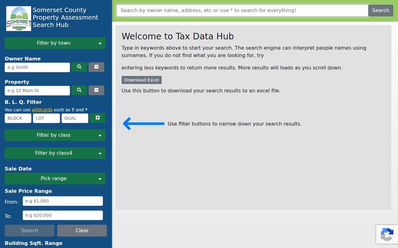
TaxDataHub is valuable after the ZIP is resolved because it searches the assessment roll on the identifiers that the roll actually recognizes. The interface documented for Somerset provides owner, property, municipality, parcel, class, sale, size, and construction-year filters. A wildcard can help with a partial owner or property string, but a broad query can reach the portal's result or download limit.
| Field | Type | ZIP-directory use |
|---|---|---|
| Town Filter | Optional filter | Limits a property query to the appropriate municipality. |
| Property | Optional text | Uses the verified street wording, not a ZIP-only query. |
| B.L.Q. Filter | Optional text | Bridges the ZIP result to block, lot, and qualification research. |
| Owner Name | Optional text | Helps only where an ownership clue already exists. |
| Sales Date or Price | Optional filter | Narrows a large result set without claiming ZIP coverage. |
| Year Built or Building Sqft. | Optional range | Provides parcel characteristics, not resident identity. |
The interface accepts * for any number of characters and ? for one character. Its current data-import notice was dated August 27, 2026. Treat that as a source date, not proof that every connected record changed on that date.
TaxDataHub's Somerset search interface shows the property and parcel filters used after a ZIP is verified.
Franklin Township ZIP Code Filter Limits
A common mistake is to assume that an assessment database will return every parcel in a postal ZIP. Franklin Township TaxDataHub did not show a ZIP field in the inspected interface. Its documented filters are Town, Owner Name, Property, B.L.Q., class, sales, building size, and year built. The county ZIP appendix is a reference list, not a parcel-level search control.
Use the ZIP as a postal check first, then search the verified street wording and Town Filter. The GIS parcel viewer can locate the block/lot, while the deed index can test a legal description. That chain keeps an address, postal route, and property record in their proper roles.
Franklin Township ZIP Code Boundaries
ZIP boundaries and township limits answer different questions. A ZIP is a postal routing device. The assessor relies on an assessment parcel, GIS maps the parcel geometry, the County Clerk indexes a legal description, and voter records concern registration residence subject to disclosure rules. None of those systems becomes interchangeable merely because an address shares a ZIP.
- ZIP Code
- A postal routing label for an address or delivery area, not a municipal boundary.
- ZIP+4
- An added postal segment that helps route mail more precisely within a ZIP code.
- PO-box ZIP
- A postal label assigned for box delivery; the research did not verify one as a Franklin Township resident-area category.
- Unique ZIP
- A ZIP used by a single institution or high-volume recipient; none was verified for Franklin Township.
- Carrier route
- A mail-delivery grouping, not a legal parcel or a public household roster.
Franklin Township's six labels are a geography lesson, not an invitation to combine unrelated records. Compare the street address, municipality, block/lot, and source date before treating two entries as the same place.
Franklin Township ZIP Code History
Historic research needs one more layer of caution. Printed directories and census schedules predate modern postal patterns and may file a Franklin household under a nearby city or a village name. Maps and street guides can connect an older route or village label to a modern parcel. They do not retroactively assign a present-day ZIP to a historic entry.
Franklin's D&R Canal corridor, village centers, rural tracts, and newer subdivisions leave different record trails. Preserve the directory's municipality code and the census geography beside the contemporary USPS result. That small separation prevents a historical convention from being mistaken for a correction to a Franklin Township address.
Note: No official ZIP split or realignment date was located for Franklin Township, so no boundary-change timeline is asserted here.